Finding Beauty with Imperfection

Category: Hiking Page 3 of 4

Mt. Fuji – Take 2

Ironically enough, Dave and I climbed Mt. Fuji the exact same weekend last summer. I was a little hesitant to climb again after our experience climbing down in the torrential rainstorm. As Sonia and I discussed expectations, I said I wanted amazing weather at the summit. I wanted pictures of being above the clouds with blue skies and a Torii gate. Realistically, I wanted it to not rain as much as it did last year. 

We took the MWR tour and left Yokosuka at 2:00 am Saturday morning. We made a brief stop in route for provisions and arrived at the 5th station of Mt. Fuji a little before 5:00 am. I decided to carry the same hiking stick from last year and fill it with stamps. This was Sonia’s first climb so she purchased a new stick to have stamped along the route. Here is the location of the 5th station. It is the furthest accessible point by vehicle. 


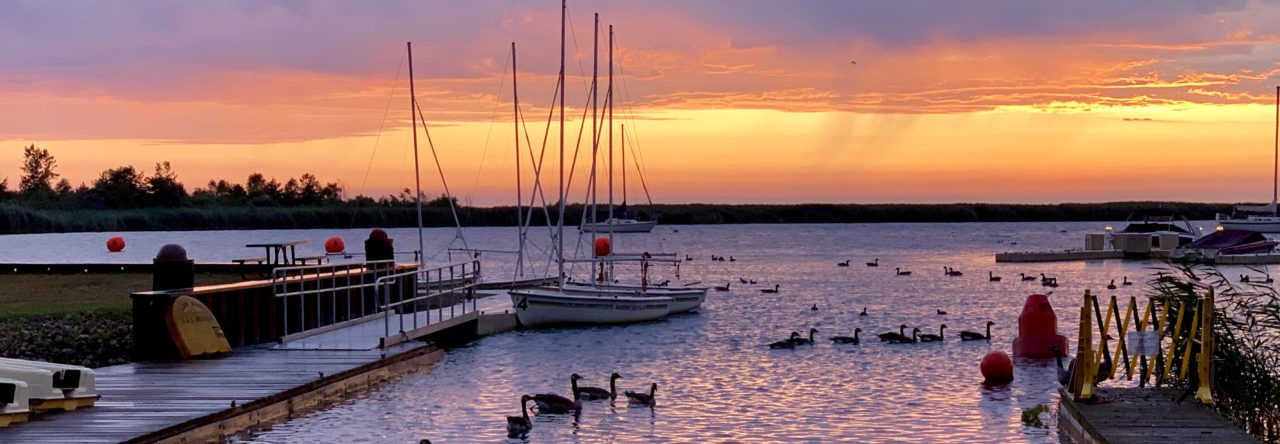
Of course, one of the best parts of the hike is seeing an amazing sunrise. 


From 5th station we begin our hike to the 6th station. This part of the hike is repeated when we come down the mountain. We took a quick picture at the 6th station before going up! If you look closely at the picture, you can see the results of the high winds. Most of the way up the mountain today, we were challenged with very strong and gusting winds. 


The hike from the 6th station to the 7th station consists of wide igneous rock covered trails with a lot of switchbacks. In my opinion, it is the most boring part of the hike. 

It was a lot of this! 


And fortunately, this! 


The 7th station is fun because here you can receive the first stamp on your hiking stick. Also, the terrain of the trail changes dramatically. There are a lot more large igneous rocks. I remembered how challenging they were last time to climb over because their texture is so rough. Today, they were exceptionally difficult because of the strong winds. At times I felt like a human sail and decided to keep my head down and hold onto the rocks with both hands! Sonia was smart and brought sunglasses to keep not only the sun out of her eyes but also dust. She was a great help to me by yelling “put your head down” when she felt a strong gust. We were covered in dust by the time we came down the mountain. 


The other important thing to note is how beautiful the skies were during this portion of our hike. It truly set the stage that I just might have my amazing views. 

From the 7th station we continued on to the 8th station. 


At 3100m, the views were still spectacular. 


We reached the 8th station just before 8:00am. Time wise, the 8th station is approximately halfway up the mountain. We had about three hours of hiking remaining before reaching the summit. We enjoyed my new favorite find at Family Mart. Cheeseburgers! 


As we were finishing up our mid morning snack, the clouds were building and rain started. Quickly we gathered our gear and started hiking again. The rain didn’t last too long! Whew! The next stop was the 8.5th station (that’s what the sign calls it!) or the original 8th station. It takes an average of 80 minutes to go from the 8th station to the 8.5th station.  The elevation change is a little over 300m. Along the way, we noticed new trail maintenance and a sign. It was fun to see “new things” on this journey! 


Through this portion of the journey, we kept good tabs on our pace and level of exertion. Knowing we had about three hours of hiking to reach the summit, we remain cautious and steady. None the less, our hearts were pounding pretty hard at times! As we passed the 3240m – 3400m elevation, we stopped for a few fun photos. 


I was able to get a good picture with a Torii above the clouds. I took time to embrace the wabi-sabi. It’s may not be at the summit but, it’s a great picture! Beauty in the imperfections. As a result, I have a cute Torii picture on Mt. Fuji. 


As we arrived to the 8.5th station, the clouds started to roll in, again. 

That’s a patch of snow! 


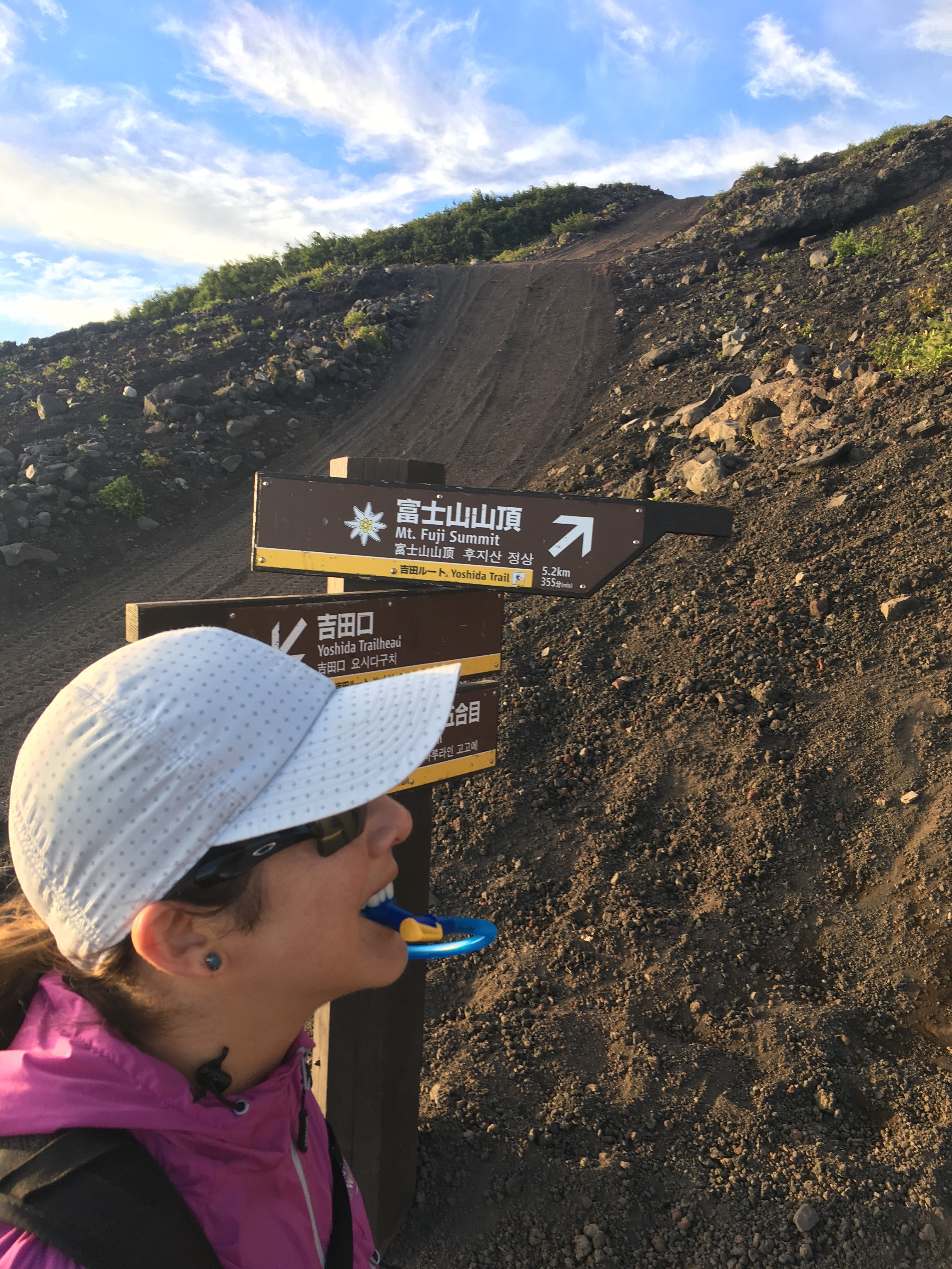
From the 8.5th station to the summit is about 90 minutes. The elevation change is a little over 300m. It was during this stretch last year when the wheels started to fall off because of the weather and our inexperience with climbing Mt. Fuji. This year, I at least knew that the 600m sign meant we still had 25 minutes of strenuous climbing! 


As we arrived at the 9th station, we were greeted by another Torii. Perfect opportunity to catch our breath and take a few photos. 


The final stretch to the summit remained. The clouds were thick. 


Off we went. One boulder scramble, stair step at a time! 


Until finally…. we made it!! Check us out! 


At the summit, we stopped for lunch. It was just before 11:00am. About 6 hours of hiking with necessary breaks. Not too shabby! Actually, 6 hours is the average. Lunch was a delicious warm bowl of ramen! By the time we reached the summit the only spot left on my hiking stick was for my second summit stamp! 


We ate, had our hiking sticks and temple books stamped, and used the restroom. By the time we were heading down the mountain it was noon and it was beginning to rain. Oh, no. I honestly didn’t know if I had the strength to endure the descent in the rain again this year. Fortunately, I didn’t have to find out. The rain stopped pretty soon after we left the summit. 

The descent without rain was so much easier. We each slipped a couple times on the loose igneous rock. But, we were ok. We were dry and warm. 


Somewhere along the descent, the clouds were beneath us and above us. 


We could stand on the ledge and I could get my cool cloud picture. 


I experienced wabi-sabi yet again. The summit isn’t the only place magical pictures can be captured. 


The remainder of the hike had a few sprinkles and maybe a slip or two. Without all the rain, coming off the mountain was a breeze. We were back at the 5th station by 3:00pm. 

We had two hours before the buses left to clean up, eat, and shop. Which we did. I enjoyed Mt. Fuji Melon Bread and a Mt. Fuji Craft beer. Delicious reward for a great hike. 


After our hike today, I’ve decided I love Mt. Fuji even more. She has a way of showing you your strengths and weaknesses when you make the climb. Mt. Fuji doesn’t give you what you want, but gives you what you need. Sonia needed to check Mt. Fuji off her Japan bucket list. She was ready for the challenges climbing Mt. Fuji would give her and she came out victorious. 

Today, I needed perspective and a dose of wabi-sabi. Finding beauty in the imperfection. Honestly, I don’t feel like I have any unfinished business with Mt. Fuji. Mt. Fuji is a good sensei (teacher). I came and I climbed – twice. For that I am wiser, not a fool! 

Working Lunch

Sonia and I met in Yokosuka today for a “working lunch”. We met at ConeLi pizzeria. Formerly known as Napoli Bar Pizzeria.


Sometime in the past few months, the restaurant has changed names. The pizza was still worthy of an honorable mention. And the perfect carbo load for the upcoming weekend adventure details we needed to work through.


You can call me a fool when I tell you the planning details we were working on at lunch. We are going to hike Mt. Fuji on Saturday. Remember this quote: “You are wise to climb Mt. Fuji, but a fool to do it twice.” I went back to reread my blog post from last August when Dave and I hiked Mt. Fuji.  Ironically, it was the exact same weekend last summer! With respect to hiking it again, I said maybe. If it was on someone’s bucket list. It is on Sonia’s Japanese bucket list and she was preparing to hike it by herself. Being a good friend, the thought of Sonia hiking by herself and selfishly, the chance to see an amazing view we didn’t see last summer… changed my maybe to a YES! Oh, boy!! 

Team Redwood 

Our next destination on our RV adventure was Redwood National and State Parks along the Northern California Coast. Redwood National and State Parks encompass a string of protected forests, beaches and grasslands.

We spent the night of Sunday 7/16 along the coast in the middle of big trees. 


Monday morning, we were up early and went to Pebble Beach to investigate tide pools. I wish you could hear the seals on the big island barking and the crashing of the waves. 


After lunch, we took a six mile hike through the Jedediah Smith Redwoods State Park. The trail took us through dense old-growth woods. There were big trees everywhere! We all took turns being trees in the trees! 


I took a picture of this branch that fell. It’s called a widow maker. Because if you’re under it when it falls, it will kill you. Notice how it stuck in the ground. And how new growth is already sprouting. The branches hold so much water and nutrients, they act as a nurse log for the new growth. 


Can you see me? 


I also saw my first banana slug. 


Dinner that night was a well earned crab feast! 


Our six mile hike was just a warm up for our 11+ mile hike on Tuesday. (Depending on whose device you checked we walked somewhere between 11 and 16 miles – but who’s counting miles when they are filled with beautiful big trees?) We took a hike to Fern Canyon in the Prairie Creek Redwoods State Park. Fern Canyon is aptly named because of its high, plant-covered walls. 


I attempted to capture the magnificent Redwoods throughout the hike. 


Both of these hikes were beyond my definition of hiking through the woods. The strength of the beautiful big trees was inspiring. I’ve seen Giant Sequoias and now I’ve seen the world’s tallest trees. Both are worthy of appreciation. However, if I must choose between the two, I stand tall with Team Redwood. 

Day Three – Yosemite Falls

Friday, was our last full day in Yosemite. Audry and I discussed possible hiking options. We both decided we wanted to avoid Vernal Falls, Mist Trail, and John Muir Trail all three were part of our hike to Half Dome. Instead, we took the Valley Shuttle to Lower Yosemite Falls. A few pictures of our approach to the falls. The first picture is Upper Yosemite Falls. 


Lower Yosemite Falls was magnificent. The extra snow and late season storms in Northern California really enabled the Falls to be a beautiful spectacle this time of year. So much energy! And wind! It’s our “Flock of Seagulls” look. 


After visiting Lower Yosemite Falls, we eventually found the trail for Upper Yosemite Falls. It was only 3.2 miles to the top. The guidebook said it would take 3-6 hours. Let’s go! 


The trail was a steep vertical ascent with countless switch backs. The views of the Valley floor as we climbed were breathtaking. Half Dome will always be one of my favorites. 


Up and up and up we continued to climb. 


After about two hours, we reached the halfway point. Here we had a stunning view of Upper Yosemite Falls.


And in the other direction, Half Dome. 


As we rested, we contemplated which direction we should go. Further up the mountain, about two more hours to the top of the Falls, or back down. We made a wise choice to head back down. By the time we were back in the Valley, We were both famished. We stopped at the Yosemite Village Grill for a cheeseburger. I quickly gobbled mine down with a Lagunitas IPA.  


We hopped the shuttle back to our tent. I attempted to convince Audry we should go see Mirror Lake. It’s flat and only three miles round trip. Nothing I said convinced her. Smart girl. It was 6:50pm. I said if I’m not back by 8:00pm, look for me. Off I went. Expediently. I only paused for a few pictures. 


Mirror Lake was pretty and serene. I’m glad I went and glad I didn’t force Audry to go. Because it was a bit anticlimactic after the earlier views and without perfect light and weather conditions. 


I returned a faster route and arrived back at our tent at 7:59pm. Audry was making preparations to come find me! What an amazing friend! Our time together was truly an adventure. Thank you for filling my happiness bucket. Xoxo 

Easy Day 

After our long and strenuous Half Dome hike (19 miles), Audry and I thought we deserved a break on our second day in Yosemite. We decided to hike along the Valley Loop Trail from Half Dome Village to Bridalveil Falls. The guide book described the hike as being an easy flat hike. This sounded delightful and manageable after the strenuous Half Dome hike. We set out with the intention of hiking four miles round trip from our tent to Bridalveil Falls. After we had been walking a while, we passed a sign saying Bridalveil Falls was 3.4 miles. Hmmmmm. That seemed longer than we expected. No worries, we can just take the free Valley Shuttle from Bridalveil Falls back to Half Dome Village. 

We continued walking and enjoyed the views the trail gave us of El Capitan. 

We could also see Upper Yosemite Falls. 

And view Bridalveil Falls as we approached. 


It was beautiful! Mesmerizing! And crowded! Strategic camera angles enabled me to crop out most of the people. 

After our visit at Bridalveil Falls, we were ready for an adult beverage. We started looking around for the shuttle stop. But couldn’t find one. We saw a sign when we passed the split for El Capitan for the shuttle and so we walked back. And had a few more chances for amazing views. 

Eventually, we found the shuttle stop and made it a little closer back to Half Dome Village before getting caught in traffic and deciding it would be faster to walk. By the end of the day, our simple four mile loop turned into 11.5 miles! Ha! Easy Day! 

We earned and enjoyed a pint. Check out what we liked to call our “Yosemite tan” – or just dirt. 

Lottery Weiners 

The popularity of hiking Half Dome in Yosemite has steadily increased over the years. To preserve the integrity of the cables, the National Park Service limited the number of daily hikers to only 300. To obtain one of the permits, the NPS instituted a lottery. The preseason lottery opens during the month of March and results are announced in April. A second lottery is held each day during the hiking season. The hiking season lottery is held 48 hours in advance of the day you desire to hike and results are announced 24 hours prior to your desired hiking day. 

Audry and I both entered the preseason lottery and neither obtained a permit. We were disappointed and knew we would try the daily lottery but, didn’t put to much hope into obtaining a permit. 

We entered the lottery on Monday, July 3rd in hopes of securing permits for Wednesday, July 5th. Audry was the winner! She was able to secure two permits for us! 

On July 4th, I left Tokyo at 8:00 pm and arrived in San Francisco at 1:30pm. Audry picked me up at the airport and we drove to Yosemite. We stayed in Half Dome Village in a permanent tent. It was getting late by the time we were settled and we tried to make it an early night because we wanted to be hiking by 5:00 am. 

And we were. We started out to Half Dome at 5:00 am and returned to our cabin just before 7:00 pm. It was a fourteen hour hike.  We checked at least 5 times along the way we had our permits for the Half Dome cables. Every time, yes! And we laughed. 


We got drenched within the first hour along the Mist Trail and Vernal Falls. 


We oohed as we hiked past Nevada Falls. 


We aahed as we hiked through the Redwoods and Sugar Pines. 


When we finally had Half Dome in our sights, we cheered. And kept climbing. 


When we reached the cables, we rested before we climbed. Guess what we didn’t have to do – show our permits to climb the cables! Yep, no one was there to check!! What??!?! All of the other hikers were just as surprised as we were. Guess the day after a holiday isn’t a very busy day! 


We conquered. 


We enjoyed the view! 


And then we hiked back down… 


And down… if only we could have rafted down the Merced River!! 

Finally, we reached the paved road. So close!


And by the time we got home, Half Dome was sleeping. 


We owned Half Dome that day. We were tested and we were victorious! 

Kamikochi 

On Saturday, Dina, her daughters, and I went on an ITT tour to Kamikochi. Kamikochi is a hiking area in the Japanese Alps. It is located in the Nagano prefecture and about a five hour bus ride from where we live. 


Out guide gave us a map of the route we should follow during our hike. The hike was advertised as being a 6-7 mile flat and easy hike. We were also told to be watchful for monkeys, deer, and bears. We only saw monkeys. 

The bus dropped us off around 9:30am. It was a clear and sunny morning. We all decided to leave our sweatshirts on the bus. 


Our first point of interest was Taisho Pond. The views were stunning in the bright sunshine and the water was so clear. 


Our next point of interest was Mt. Yakedake, an active volcano. 


We continued along the nature trail and had our first monkey sighting. We were warned not to look them in the eye! 


We continued along the trail and crossed a couple bridges and went past a shrine. 


It wasn’t too much further when we saw our first bear sighting sign report. We appreciated the sign also being in English. Fortunately, the sighting was almost a month ago. 


More beautiful views. 


And soon we made it to the Kappa Bridge. We stopped briefly for a little souvenir shopping and for a quick lunch. I took this picture when we first arrived. 


By the time we were leaving, the clouds had rolled in and it was starting to sprinkle. We had no rain gear or jackets. Fortunately, we were able to purchase new fleece for everyone! Here is the view from the Kappa Bridge. 


And oh, was it ever windy! Here we all are decked out in our new fleece. 


Being the super troopers that we are, we set out for the remainder of the hike. It was approximately 4 miles. In the light rain at first and then very heavy rain. 


At one point we all started to have Mt. Fuji climbing flashbacks. Even though we didn’t climb Mt. Fuji on the same day, we had very similar experiences. Rain. 

I took a quick recording of the rain sheets coming down. 

We were completely unprepared for foul weather during this hike. Dina mentioned the irony of us not being prepared for rainy season especially after I discussed in yesterday’s blog! Live and learn and pack a rain coat. The turn around point was across the Myojin Bridge. 


We made one more quick stop for energy aka Sake.  


After this last stop, we quickly scampered back to the Kappa Bridge area where we would find the bus. 


We had one more chance to see a monkey. 


And another bear sighting report. When we realized how recent this sighting was and that we should be especially cautious in rain, we really started to scurry! 


But first, one more selfie… 

And me with my new Wabi-Sabi Sole SnapBack and fleece. 


The day started out beautifully and turned into one of those days we will always remember. There was Eme almost falling in a puddle, no one having gear, and Dina getting snarled at by a monkey. Or maybe it was running back to warm up, playing tag, and silly science puns to keep us all laughing. Regardless, we made the entire hike (4 of the 6 people on the tour who did) and laughed more than we complained along the way! 

Jogashima Park

Jogashima Park is located at the Southern tip of the Miura Peninsula. I am the blue dot in Zushi and Jogashima Park is the red marker at the bottom. 


It has been on my list of places to visit for a couple months. We had another glorious spring day that demanded an outdoor exploration. I was able to convince Sonia to go with me and she convinced me we should take the train and bus vice driving. This would be my first Japanese bus experience! 

We met in Yokosuka and headed south on the train and then further south on the bus. Here was a shot from the bus ride. To ride the bus, you can use the same pass that is used to ride the train. You just have to remember to swipe it when you board. We missed that the first time and the driver adjusted our fairs when we exited the bus. 


I forgot to screen shot the trip down, here is the shot from the trip home. 

The grey stops are the bus stops. The bus wasn’t very intimidating after all. Pretty simple. Google Maps once again helped me navigate there and back without issues! 

Jogashima Park was beautiful! The views of the water and horizon were impressive. 


The trails were a combination of pavement, stairs, and dirt. Overall, it was very easy to navigate the park with the many cute signs directing the way. 


Besides the Japanese Seahawks, we also saw the country’s largest earthworm! 


In several places along our hike, the water was so clear! 


Simultaneously, the rock formations made me turn into a little bit of a Science geek on Sonia. She laughed and was a good sport about my teachings. These guys paid me little attention… 

Maybe my favorite picture of the day. 


We continued on our hike to the lighthouse and enjoyed more amazing views and lunch along the way. 


For lunch, we ate ramen and black vanilla ice cream. Whitebait (whitefish) was also a flavor. Gross. Almost as gross as corn ice cream. The black vanilla ice cream was very good. It tasted like vanilla! 


After lunch, we walked around a little more and found more beautiful rocks and a shrine. Also, on a clear day, we would have been able to see Mt. Fuji across the water. 


Finally, one last set of stairs took us up to the lighthouse. 


We shopped at a couple cute local stores as we headed to the bus stop. We wondered if it would be difficult to find the bus…. nope. Not too difficult in the least! 


I am super proud of myself. I can now add “capable of taking the bus” to my Japanese transportation resume thanks to Sonia’s encouragement! 

Mt. Nokogiri

Dave and I took an ITT trip with Sonia and her husband, John, to Mt. Nokogiri on Sunday. Mt. Nokogiri is located on the Chiba Peninsula. The Chiba Peninsula is on the other side of the Tokyo Bay from where we are on the Miura Peninsula. The bus ride on the way there took us through the Aqualine. 


The Aqualine is a tunnel that goes beneath the Tokyo Bay. I timed our transit. It took us a little over eight minutes with no traffic. Once we were through the tunnel, we stopped at the rest stop to purchase snacks for our hike. The views were incredible. 

It reminded us of the Chesapeake Bay Bridge Tunnel. But, in Japan, not quite as long, and with a better rest stop! 

Dave & Julia Sashimi

Taking the helm

Tokyo skyline – Tokyo Skytree is on the right. 


Here was a cool illustration of the Aqualine. 


Once we arrived at Mt. Nokogiri, we took a cable car to the top of the mountain. The views were spectacular throughout the day. We all agreed, this tour is worth doing again in the fall when the leaves are changing. 

One of the scenic lookouts was beautiful. Sonia and I waited in line for 35 minutes for these pictures! First, the line… 


And then the views! 


We walked up and down so many stairs on the mountain. Along the way, we observed 1,500 stone figures of different Arhats (Buddhist Saints). I captured a lot of them and only will share a few pictures of them! Many of the statues are in poor condition as a result of an anti-Buddhist movement during the Meiji Era (1868-1912). The statues have been under repair during recent years. 

His green head looks a bit alien-like!

Watch your head… the statues are missing theirs!


The highlight of Mt. Nokogiri is the stone Buddha (Daibutsu). The stone Buddha is the largest in Japan. It measures 28 meters high. It was built by Jingorō Eirei Ōno and his 27 apprentices. They completed the structure in 1783. It was recently restored between 1966-1969. The Daibutsu was constructed to symbolize world peace and tranquility. It was ahh-mazing. 


Dave, me, and Buddha! 


And a selfie, of course – the filters were a bonus. 


The shrines around the temple included thousands of small Buddhas. 


Just a few pictures of the flowers on the mountain before we head home.  


To return home, we took a ferry across the Tokyo Bay to Kurihama. This is the alternative route to get across Tokyo Bay. 


The ferry ride was the perfect end to a great day. Enjoying time underway with friends and adult beverages. Kanpie! 

One More Sakura Adventure 

Tuesday it rained and rained. It was pretty ridiculous. If this isn’t the “rainy season” I’m not sure I’m gonna make it without owning a canoe! Haha

The clouds finally parted and Wednesday started off beautifully. Dina and I had plans to hike to Mt. Miurafuji and to visit the cemetery pagoda in hopes of catching a few remaining Sakura.

We set out on the hike I did last month to Mt. MiuraFuji and made the steep climb. Unfortunately, today was not a clear enough day to see Mt. Fuji. The blue skies want to promise you otherwise. None the less, the views along the hike were stunning. If we were going to see Mt. Fuji, it would be in the first picture.


At the top, we made the decision to head towards the Nobi train station. There was a trail and a sign pointing the way and I thought this might connect us to the pagoda faster. Simultaneously, we knew we wouldn’t see Mt. Fuji anywhere else on the hike. So, the pagoda became our next goal.

Off we set, back down the mountain.


Soon we came to a fork in the path and a sign. Google Maps helped to point us in the correct direction. We veered right at the fork.


Down we went.


It doesn’t look very steep from the top. How about from the bottom!


We continued hiking down and found a beautiful little over look. The dark spots in the photo are Sakura petals falling. It was so serene.


We were eventually dumped out into urbanization. We followed Google Maps to the cemetery. On our journey, we passed through a quaint little park and beautiful cemetery. Both with Sakura trees in bloom.

My beautiful friend! How is she not a sweaty mess?

Me… Sweat-a-Saurus Rex! Honestly, who cares about me! Look at those Sakura Blossoms!


Ok, enough with the suspense already, we made it to the cemetery. First stop, Buddha.

This view!


A few more steps and the pagoda was in sight!


The Sakura trees in bloom with the pagoda were well worth the hike. Dina and I picked up onigiri for lunch and had our own Hanami under the Sakura trees. It was perfect. Except we forgot the Sake!!

I think the first picture is my favorite. Or maybe the second…


By the time we stopped for Hanami, I was pretty hungry. I snapped these pictures after we both finished our onigiri. Oops! It was a beautiful setting!


As we returned home on the train, clouds started to roll in and so did a few sprinkles. By the time I was walking up the hill towards home, it was full on raining. I had no umbrella, just more beautiful Sakura and a chu-hi!


Kanpie!

Page 3 of 4

Powered by WordPress & Theme by Anders Norén